
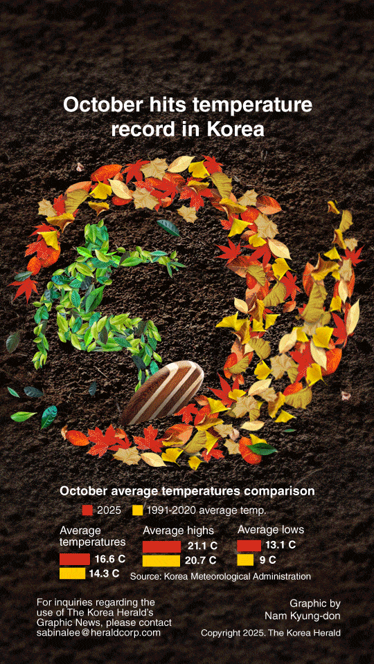
This October, South Korea experienced unseasonably warm temperatures and frequent rainfall. The nationwide average temperature reached 16.6 degrees Celsius, 2.3 C above normal, the highest in 53 years.
올해 10월 전국 평균기온이 16.6도로 평년보다 2.3도 높게 나타나, 53년 만에 가장 높은 수치를 기록했다. 전국 곳곳에서 이례적인 고온 현상과 잦은 강수가 나타났다.
Early and mid-October were dominated by warm, humid air from the North Pacific High, pushing averages to 20.1 C and 18.2 C, with daytime highs exceeding 30 C in Boryeong and Wando. Goheung and Seogwipo recorded their latest tropical night on Oct. 13.
10월 초·중순에는 북태평양고기압에서 유입된 따뜻하고 습한 공기의 영향으로 평균기온이 각각 20.1도, 18.2도를 보였다. 보령과 완도에서는 낮 기온이 30도를 넘기도 했으며, 고흥과 서귀포에서는 10월 13일 올해 가장 늦은 열대야가 관측됐다.
Late October brought colder air from continental high pressure, resulting in first frost and ice appearing 9-10 days earlier than last year in inland regions.
10월 말에는 대륙고기압에서 유입된 찬 공기의 영향으로 기온이 급격히 떨어졌다. 내륙 지역에서는 첫 서리와 얼음이 지난해보다 9~10일가량 일찍 나타났다.
Rainfall and rainy days also reached record highs, with 173.3 mm over 14.2 days nationwide, including 22 consecutive rainy days in Gangneung — the longest streak since 1911.
전국 평균 강수량은 173.3mm, 강수일수는 14.2일로 모두 역대 최고치를 기록했다. 강릉에서는 22일 연속 비가 내려 1911년 관측 이래 가장 긴 연속 강수일을 보였다.
Sea surface temperatures hit 23.3 C nationwide and 25.9 C in the South Sea, the highest in the past decade.
전국 평균 해수면 온도는 23.3도, 남해는 25.9도로 최근 10년 사이 가장 높은 수준을 기록했다.
khnews@heraldcorp.com


